https://media.ccc.de/v/bucharest-285-open-green-map-a-geospatial-tool-for-sustainable-living
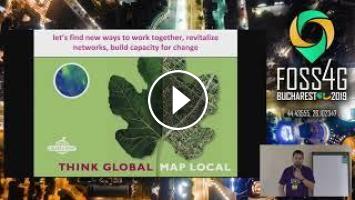
Created to serve a locally-led global map making network, the original Open Green Map (OGM) - www.opengreenmap.org, a social mapping platform, was launched by Green Map System in 2009. In the decade since, an 8 language interface and mobile site collector are among the features that attracted users in 40 countries. Dubbed ‘open’ as sites could be enhanced by the public, more than 40,000 sites were added to the OGM locally on 600 unique maps. Many of these maps became the backbone for local engagement projects and led to interactive spin off editions, print maps, experiences and media projects.
Already recognized in 65 countries, Green Map Icons bring a wide range of sustainability resources to light. These lively symbols identify, promote and link local resources in an eye-catching, easy to grasp manner that systematically connects themes and places in meaningful way.
Green Map has always served a mixed group of participants, including NGOs, schools and local governments. Since the globally-designed set of shared icons date to 1996, for many early users, Green Map was their first internet project. These evolving Icons have been provided as a font so they could be used with any graphic design or GIS application.
None
Ciprian Samoilă Wendy Brawer
https://talks.2019.foss4g.org/bucharest/talk/W7JXB9/
- Category
- Sustainable Living & Environmental Conservation
- Tags
- foss4g, bucharest, foss
Be the first to comment
Up Next
Autoplay
-
59:03

Michael Edelstein on MMVC14 and Healthy and Sustainable Living MOOC
-
39:48
Life is Good ~ sustainable living ~ Documentary in Eng.&日本語
-
52:35
Matrix in the French State What happens when a government adopts open source & open standards for a…
-
38:14
Fun Tips for Sustainable Living with Aware Animals
-
39:18
POC21 - Design for sustainable living.
-
39:14
Simple and Sustainable Living in a Tiny House!
-
25:50
SUSTAINABLE LIVING KITCHEN ESSENTIALS | Honestly Alessandra
-
1:06:50
Open seminar | Human rights and the conservation and sustainable use of biological diversity
-
20:05
EXPENSIVE INDOOR GARDEN HOUSE DESIGN: ELEVATING HOME INTERIORS WITH GREEN LIVING TRENDS
-
55:07
Sustainable living | Wikipedia audio article
-
24:56
Jim Rohn Habits To Build A Better You Personal Development - Motivational Speech
-
30:43
EMOTIONAL INTIMACY IN RELATIONSHIPS || AUTHENTICITY AND VULNERABILITY WITH DR. ANDREW BLACKWOOD
-
32:46
FREDTalks about Self-Care during times of crisis.
-
32:28
Jim Rohn - Time Management (Personal Development) How to use your time wisely.
-
59:03
Personal Growth that Doesn't Suck, Mark Manson
-
19:38
Jim Rohn Motivational Video - The 5 Year Goal Plan - Personal Development
-
1:45:15

Imam Tom Facchine - Self-Development, Languages, Problems of Modernity, Attaining Balance & More!
-
00:14
Jim Rohn - Income does not far exceed personal development
-
52:58

The Positive Power of Personal Development Books - BookThinkers (Full Episode 197)
-
03:00

Personal Development vs Magical Growth | #magic #occult